Guides · Marco Island, Florida
Marco Island History: Calusa, Canals & Key Marco Cat
Marco Island's Hidden History Beneath the Canals
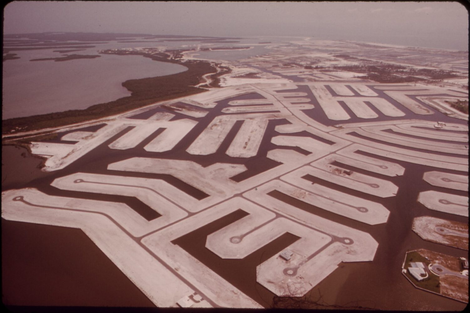
Fifteen hundred years of Calusa presence sits beneath a decade of dredge and fill. Read both timelines at once—the Key Marco Cat in a museum, the grid of canals outside—and you get the real story of Marco Island.
The Calusa lived here from about 500 CE, long before the name Marco attached to anything but the archaeological site that made it famous. Frank Hamilton Cushing's expedition recovered the Key Marco Cat in 1896. The small carved wooden figure became one of the finest pre-Columbian artworks found in North America—a reminder that this ground held deep meaning before the dredges arrived. The modern island was made by the Mackle brothers of the Deltona Corporation, who bought the land for $7 million and developed it through the 1960s. Marco Island reincorporated as a city on 28 August 1997. The island is a palimpsest: the old layers never erased, just buried under a single decade of construction.
How the Mackle Brothers Reshaped Marco Island's Coastline
The Mackle brothers didn't build on Marco Island so much as rebuild it. Their $7 million purchase launched a transformation that turned a Calusa island into a retirement and tourist destination in one decade. The natural terrain of shell mounds and mangrove-lined shores became a dredge-and-fill grid of canals. An engineered landscape that reshaped the shoreline itself. Where the Calusa moved with the tides, the Mackles moved the land. The contrast isn't subtle: the island's "old" ground is under the mangroves and the museum. Nearly every shoreline you see was shaped by machines in the 1960s.
See the Key Marco Cat at the Historical Museum
The Marco Island Historical Museum anchors any attempt to understand the island's deep time. Inside, the Key Marco Cat sits on loan from the Smithsonian—not a replica, but the actual artifact recovered in Cushing's 1896 expedition. The museum frames the juxtaposition of eras directly: the Calusa presence from 500 CE, the archaeological fame of Key Marco, and the Mackle development layered on top. It's the one place on the island where the full timeline is laid out in order. A rare moment of clarity in a landscape that otherwise reads as purely recent.
Marco Island Restaurants Reflect the Dredge-and-Fill Grid
The dining scene is a map of the island's recent construction. Reading it tells you where the fill went. Waterfront spots like Snook Inn and Mango's Dockside Bistro sit on canals, their identities tied to the dredged waterways that define modern Marco. Inland, Doreen's Cup of Joe and Joey's Pizza & Pasta House occupy strip malls along Collier Boulevard, the spine of the developed island. CJ's on the Bay, Sami's, DaVinci's, The Deck at 560, Sunset Grille, STONEWALLS, Marco Prime Steak & Seafood Restaurant, The SpeakEasy Marco Island, LeeBe Fish, The Crazy Flamingo, and 2Shea's Salty Dog round out a scene shaped entirely by where the dredges ran and where the buildings went up. Even McDonald's on N Collier Boulevard is part of the same story. The island's built environment determines where you eat, how you get there, and what you see while you do.
Tigertail Beach: An Engineered Shoreline on Marco Island
Tigertail Beach is one of the island's two public beach accesses with parking and amenities. But it's not a natural shoreline in any pre-1960s sense. The developed island manages its coastline the way it manages everything else: engineered, maintained, and accessible. The beach experience reflects the place—a managed edge where the dredge-and-fill grid meets the Gulf. A boundary that exists because the Mackles decided where it should be.
Marco Island Demographics: Seasonal Homes and Retirees
The census numbers tell the newest layer of Marco's story. The median age is 67.7 years. Of 18,436 total housing units, 9,264 are held for seasonal or recreational use, and 10,003 are vacant. Median household income sits at $104,105; median home value at $866,200; median gross rent at $1,955. The unemployment rate is 4.2 percent, and 47.9 percent of residents hold a bachelor's degree or higher. This is a seasonal retirement destination. A population of 15,998 people that swells with snowbirds and empties out in the off-season. That layer of history sits on top of the Calusa and the Mackles—the latest in a series of transformations that never quite erased what came before.
| Era | What Remains |
|---|---|
| Calusa presence, from 500 CE | Shell mounds, archaeological sites, the Key Marco Cat |
| Cushing's 1896 expedition | The Key Marco Cat, displayed at the Marco Island Historical Museum |
| Mackle brothers, 1960s | The canal grid, dredge-and-fill shoreline, developed island |
| Reincorporation, 28 August 1997 | The modern city of Marco Island |
| Present day | Seasonal retirement population, 9,264 seasonal homes, 10,003 vacant units |
Common questions
- What is the history of Marco Island?
- The Calusa lived here from about 500 CE. The modern island was built by the Mackle brothers of the Deltona Corporation, who bought the land for $7 million and developed it through the 1960s. Marco Island reincorporated as a city on 28 August 1997.
- Where can I see the Key Marco Cat?
- The Key Marco Cat, a small carved wooden figure recovered in Frank Hamilton Cushing's 1896 expedition, is displayed at the Marco Island Historical Museum on loan from the Smithsonian.
- What are the best-rated restaurants on the island?
- Top-rated spots include Doreen's Cup of Joe (4.6), DaVinci's (4.7), The Deck at 560 (4.7), LeeBe Fish (4.6), and Sami's (4.5). All are local favorites with strong reviews.
- Is Marco Island crowded or quiet?
- With a population of 15,998 and a median age of 67.7, it's a quieter, retiree-oriented destination. Of 18,436 housing units, 9,264 are for seasonal or recreational use, so it empties out off-season.
- What beaches are public and easy to access?
- Tigertail Beach is one of the island's two public beach accesses with parking and amenities. It's a good spot for a straightforward beach day without resort fees.
- Can I visit nearby towns for day trips?
- Yes. Everglades City is 23 miles away, Arcadia is 90 miles, and Okeechobee is 109 miles. Each has its own annual festival, like the Everglades Seafood Festival or the Arcadia All-Florida Championship Rodeo.
Every business named above is one we hold a listing for, and every date traces to a source on our sources page. We do not describe menus, interiors or service we have not verified. Details change — confirm before you travel.